The empty reservoir is the iconic image of California’s severe four-year drought. California’s big reservoirs actually rise and fall every year, filling with rainfall and snowmelt in the winter and developing a “bathtub ring” in the summer as they supply farms and lawns through the dry season. For three winters, though, rain and snow failed to fill the reservoirs: from 2013 through 2015, Shasta Lake never reached capacity, entering the dry season already depleted.
Hoping that this winter would be different, I scraped an image every hour from two Caltrans traffic cams that happen to capture Shasta Lake in the background. Stitched together, they show California’s largest reservoir rising 144 feet and tripling in volume between December and May as it swells with rainfall and snowmelt.
Here’s the same bridge from a different camera. This camera is on top of a mountain and seems to get blown around in bad weather, so it’s all over the place.
The reservoirs may have refilled, but we’re not off the hook. California is still in a drought, and climate change will make severe droughts more frequent. Much of the state’s groundwater has been overdrawn beyond any hope of recovery, so we’ll have a much smaller cushion next time the rain stops. And an essential feature of the water system is that snowpack in the Cascades, Klamath Mountains, and Sierra Nevada melts gradually over the early summer, replenishing the reservoirs as farms ramp up usage—but that snowpack is still well below average, which means that Shasta Lake will likely be alarmingly low again by the end of summer.
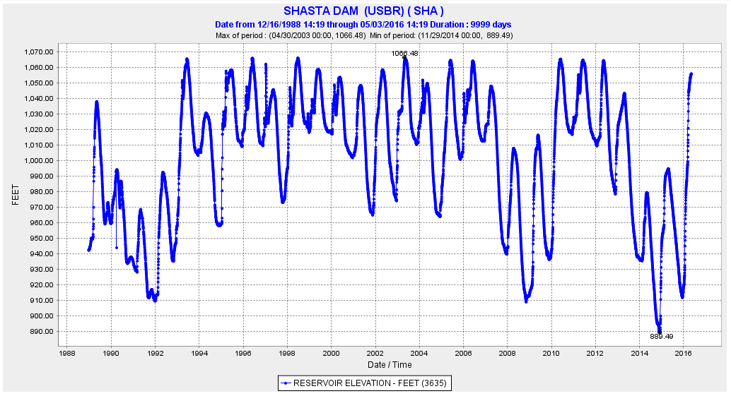
The West’s water system is incredibly sophisticated—a monumental engineering effort to move water from wet areas to dry ones and harvest power as it descends from the mountains. Water from this lake goes into the Sacramento River, and just before it would flow into San Francisco Bay giant pumps lift it into canals that carry it down the Central Valley. To me, these animations speak to the scale of these waterworks: vast lakes fill and drain at the command of civil engineers! (Back in 2011, I wrote about something similar for Forbes: how giant dams stop and start the Columbia River every day to match electricity supply to demand.) Here’s the elevation of Shasta Lake’s surface over the last 10 years:
When Shasta Lake was very low, it revealed another hint at its scale: highways and railroads were inundated when the reservoir was filled, and they’re still there, under the water. The Pit River Bridge, which carries Interstate 5 in the animations above, appears to float just above the surface of the lake when it’s full, but in fact it crosses a deep canyon on tall pylons. Here it is before the lake was filled, in photos from the University of California collection; the left image shows the original road crossing of the Pit River, which is now well under the surface of the water.
If you’re interested in knowing more about how the water system works in the western United States, I highly recommend Marc Reisner’s classic Cadillac Desert. Shasta Lake, in all its vastness, is just a small part of an enormous system that sends water from the rainy parts of California to the sunny parts so that we can have fresh strawberries in February and bright green lawns in the middle of a desert.
For roughly a century it was common belief that engineers could reorganize nature entirely and bring it into submission. Lyndon Johnson summarized that audacious belief in his inaugural address, near the end of that era:
For this is what America is all about. It is the uncrossed desert and the unclimbed ridge. It is the star that is not reached and the harvest that is sleeping in the unplowed ground. Is our world gone? We say farewell. Is a new world coming? We welcome it, and we will bend it to the hopes of man.